Yesterday, Saturday, was probably the warmest day since I arrived. Here in my house it was already getting too hot inside by 09.00 and so, despite a restless night, I decided to get out and enjoy the day. First I though I'd traverse the Eastern Walkway on the Miramar Peninsula just across the bay. But fearing the revenge of the sun and possible inefficiency of my sun screen I came to the conclusion that it'd be more fun and challenging, and involve the higher possibility of walking in shade, to make the 45 minute drive out to the Rimutaka forest Park for another trek there.
For this week's trek I had made some critical decisions in advance; take walking boots and socks instead of sturdy sandals, carry a spare t-shirt and shorts, sun screen just in case, as well as a packed lunch and 3 bottles of ginger beer, wrapped in foil to keep them cool for as long as possible. Certain items that are usually considered good practice were not taken; maps (don't have any), compass (don't own one here), matches (why?!), water (ginger beer gives more energy), plasters in case of injury and spare walking socks and warm clothes in general.
My guide book of Wellington walks explained the Butcher Track thus, '...begins not far along the Orongorongo Track and climbs about 1.5 km, partly through attractive beech forest, to a ridge which offers good views of the harbour, particularly from the nearby 465 metre high Baker peak. The option is to return the same way, or better (my emphasis), continue along the Cattle Ridge Track which joins the Orongorongo Track near Jacobs Ladder.' From last week's experience I knew that a return trip straight to the Orogorongo river from the car park is at least a 4 hour walk. Well, there are timings on the many information points and direction signs along the path. Setting off from the car park at 12.30 and having ample time (as the park gates are locked for the night at 20.00) I decided to make the exerting trip up the Butcher Track and aimed to continue on the better route, down to the river and from there make the 2 hours' trek along the Orongorongo track back to the arse rocket in the car park.
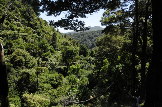
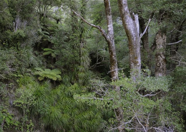
Being alone has advantages for someone who is keen to photograph everything of interest along the way and, in my case, to also record the forest sounds with my iPhone using a software package called iTalk that produces rather high quality recordings for 'a phone'. If you walk in a group you soon get a bad reputation for slowing everyone down. Of course, the photo or sound 'opportunity' is also an excuse to stop in those moments when it feels like your lungs are really not getting enough oxygen into your body. There were quite a few of those moments on the steep and shady incline up the Butcher Track. By the time I got to the ridge I'd already managed at least 20 minutes of recording of birds and the general cacophony of the crickets. The attractive beech forest was also well recorded.


At the top of the path there was a sign showing the direction and distance down the path I'd just trodden but, unfortunately, no sign to show how to find the Cattle Ridge Track. After stumbling down through thistle bushes on what could have been a path I decided that it was definitely the wrong way but probably OK for sheep. Never mind, nothing for it but to turn round and head back up hill in the sun to where I'd started. And then an idyllic rest in the shade of the trees, on the other side of a gate on a track leading hopefully in the right direction. Rejuvenated I followed the track to the yard of an uninhabited modern holiday chalet, with wonderful views over the valleys to the sea and, behind another little rise in the back yard, its own wind farm.

From here it was clear that this was the Cattle Ridge Track, because it was surely wide enough for cattle and there were 'signs' that large beasts had moved this way. A little way further along the track, in the midst of a rather mature pine plantation, the path split, the left fork doubling back on the outside of the forest, obviously a newer track made for forestry work I assumed. I continued along the main track, easy going underfoot on a cushion of massive fallen pine needles, and enjoying great shade from the heat of the midday sun. At the edge of the forest the path became narrower and followed the ridge down through thistle bushes. From time to time there were signs that someone had been making maintenance pruning, in order to make the walk a bit more bearable.

But, in general, the path appeared to be narrowing and the thistles were increasing the discomfort to my exposed arms and legs alike. No turning back at this stage anyway, because already the river valley was in sight, although maybe a few kilometres away and 500 metres or more below.


Having also traversed a few major mud and slime pools along the track I was rather happy that I was wearing my boots and not the sandals. That sentiment was reinforced when I eventually got down to the river itself as the walking there, on loose stones and sand, and over all kind of natural debris was immediately a challenge for my balance and my ankles. It did come to mind that since leaving the top of the Butcher Path, an hour or so ago, I had not seen any direction signs, although I'd noticed the occasional blue or red plastic tie-marker in the trees along the way. I'd also not seen anybody since starting to climb up the Butcher Track around 12.30. At the back of my mind there was a growing fear that maybe my route down was not, in fact, the one mentioned in the guide book; the one without maps. The journey down from the wind farm had taken at least an hour and at a good downhill pace this meant that I'd traveled at least 5 kms.
The first challenge once down on the river was to get across it, in order to then start making the trek back up the river to the start of the Orongorongo Forest Path. So, for the first but not last time that afternoon, it was off with socks and boots and then a careful paddle across the shallow river being careful not to fall accidentally and give my new Nikon its first (and potentially last) bath. The water was a cooling comfort, but the sharp stones alongside pointed to the already tired and sensitive nature of my suffering feet. The water was very tempting despite the slimy algae along the edge of the stream. It was time for a dip; a classic uplifting moment on any tough, hot trek: Man and nature at one with each other.
Dried, rebooted and with ample sun screen applied I continued my adventure upstream with comfort factor improved also by a new dry t-shirt. The earlier one was wetter than the river at this point. I imagined that the meeting point with my return path would be a kilometre or so up stream. The appearance of a family in a 4-wheel drive making its way downstream removed any doubts about this for at least for 30 seconds. Obviously it's unusual to find someone making their way up the river and so they pulled alongside and asked if everything was OK, which it was, of course! These were locals, on their way down to their bach (holiday cottage/mökki) downstream. So I confirmed that I was going in the right direction but their estimate of the distance to the path was...1.5 hours minimum. I was given some water and informed that, anyway, it was perfectly safe to drink from the river.
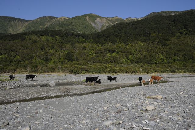
The news of the forthcoming stage of this Saturday tramp was a little disheartening as I had rather hoped that the text of the guide was correct, that I was actually following it correctly, and that the path I had planned to return on was around the next bend. Two hours later, after tramping slowly up the river, over the river, around the river and through the river (and for most of the time striving to keep boots and camera dry) with the afternoon sun on my head and back I was greeted by the sign of some sort of human existence. Along the way I'd witnessed some magnificent forest including a few huge (> 20m) ancient Northern Rata and had familiarised myself with the realities of a river bed in summertime, experienced by just me, a few sheep and a small herd of cows.


Swimming kit drying on a bush marked the place of a communal trekking hut, inhabited by several families, a lot of small kids and a very cute Labrador puppy. I gained updated instructions from the people there and quickly found the start of the forest path, marked by a handsome arched wooden bridge a little further up the river. They guestimated that it would take me 50 minutes back to the car park. After the first few climbs on the path I realised I was getting low on energy and rested on a well positioned bench for a few minutes and ate some fruit. Since starting to make my way up the river I'd also consumed at least 2 litres of it, now stored in the emptied ginger beer bottles.
The time was approximately 18.30, so there was a good chance of getting out of the park before the lock up at 20.00. After the first climbs in the path the going got much easier and now it was possible to use the path direction signs to judge distances. However, it seemed that this path was supposed to be walked in 90 minutes. I realised I had a hurry after all.
With new energy I surprisingly made quick progress, stopping occasionally for a breather, a photo or to record the wonderful bird calls in the high trees.

Later, at about 7.20 I met a couple heading for the river to camp. They reckoned I still had about 20 minutes to the car park. In reality they too were about 20 minutes off target in their estimation. The next direction sign read, 'car park 40 minutes'. So now, after almost 7 hours of walking I was left with the option of a night sleeping in the Toyota Starlet or increasing my pace to avoid that nasty fate, and making it home to a decent meal and a long hot bath. Both scenarios were good reason to start jogging/running at this point and, despite the nagging complaints of feet, toes and legs I made it back to the car with 10 minutes to spare. Even with the arse rocket's lack of suspension I also made it over the ten or so 'sleeping policemen' (töyssyt) on the drive out of the park without parting with the exhaust system and still made it to the gates with 5 minutes to spare before closing time.
What a sense of achievement and adventure the day had provided! And, in retrospect, and taking into account other possible scenarios, what a lot of lessons I've learned!
On a trek always take:
(All photos with Nikon D300).
For this week's trek I had made some critical decisions in advance; take walking boots and socks instead of sturdy sandals, carry a spare t-shirt and shorts, sun screen just in case, as well as a packed lunch and 3 bottles of ginger beer, wrapped in foil to keep them cool for as long as possible. Certain items that are usually considered good practice were not taken; maps (don't have any), compass (don't own one here), matches (why?!), water (ginger beer gives more energy), plasters in case of injury and spare walking socks and warm clothes in general.
My guide book of Wellington walks explained the Butcher Track thus, '...begins not far along the Orongorongo Track and climbs about 1.5 km, partly through attractive beech forest, to a ridge which offers good views of the harbour, particularly from the nearby 465 metre high Baker peak. The option is to return the same way, or better (my emphasis), continue along the Cattle Ridge Track which joins the Orongorongo Track near Jacobs Ladder.' From last week's experience I knew that a return trip straight to the Orogorongo river from the car park is at least a 4 hour walk. Well, there are timings on the many information points and direction signs along the path. Setting off from the car park at 12.30 and having ample time (as the park gates are locked for the night at 20.00) I decided to make the exerting trip up the Butcher Track and aimed to continue on the better route, down to the river and from there make the 2 hours' trek along the Orongorongo track back to the arse rocket in the car park.
Being alone has advantages for someone who is keen to photograph everything of interest along the way and, in my case, to also record the forest sounds with my iPhone using a software package called iTalk that produces rather high quality recordings for 'a phone'. If you walk in a group you soon get a bad reputation for slowing everyone down. Of course, the photo or sound 'opportunity' is also an excuse to stop in those moments when it feels like your lungs are really not getting enough oxygen into your body. There were quite a few of those moments on the steep and shady incline up the Butcher Track. By the time I got to the ridge I'd already managed at least 20 minutes of recording of birds and the general cacophony of the crickets. The attractive beech forest was also well recorded.
At the top of the path there was a sign showing the direction and distance down the path I'd just trodden but, unfortunately, no sign to show how to find the Cattle Ridge Track. After stumbling down through thistle bushes on what could have been a path I decided that it was definitely the wrong way but probably OK for sheep. Never mind, nothing for it but to turn round and head back up hill in the sun to where I'd started. And then an idyllic rest in the shade of the trees, on the other side of a gate on a track leading hopefully in the right direction. Rejuvenated I followed the track to the yard of an uninhabited modern holiday chalet, with wonderful views over the valleys to the sea and, behind another little rise in the back yard, its own wind farm.
From here it was clear that this was the Cattle Ridge Track, because it was surely wide enough for cattle and there were 'signs' that large beasts had moved this way. A little way further along the track, in the midst of a rather mature pine plantation, the path split, the left fork doubling back on the outside of the forest, obviously a newer track made for forestry work I assumed. I continued along the main track, easy going underfoot on a cushion of massive fallen pine needles, and enjoying great shade from the heat of the midday sun. At the edge of the forest the path became narrower and followed the ridge down through thistle bushes. From time to time there were signs that someone had been making maintenance pruning, in order to make the walk a bit more bearable.
But, in general, the path appeared to be narrowing and the thistles were increasing the discomfort to my exposed arms and legs alike. No turning back at this stage anyway, because already the river valley was in sight, although maybe a few kilometres away and 500 metres or more below.
Having also traversed a few major mud and slime pools along the track I was rather happy that I was wearing my boots and not the sandals. That sentiment was reinforced when I eventually got down to the river itself as the walking there, on loose stones and sand, and over all kind of natural debris was immediately a challenge for my balance and my ankles. It did come to mind that since leaving the top of the Butcher Path, an hour or so ago, I had not seen any direction signs, although I'd noticed the occasional blue or red plastic tie-marker in the trees along the way. I'd also not seen anybody since starting to climb up the Butcher Track around 12.30. At the back of my mind there was a growing fear that maybe my route down was not, in fact, the one mentioned in the guide book; the one without maps. The journey down from the wind farm had taken at least an hour and at a good downhill pace this meant that I'd traveled at least 5 kms.
The first challenge once down on the river was to get across it, in order to then start making the trek back up the river to the start of the Orongorongo Forest Path. So, for the first but not last time that afternoon, it was off with socks and boots and then a careful paddle across the shallow river being careful not to fall accidentally and give my new Nikon its first (and potentially last) bath. The water was a cooling comfort, but the sharp stones alongside pointed to the already tired and sensitive nature of my suffering feet. The water was very tempting despite the slimy algae along the edge of the stream. It was time for a dip; a classic uplifting moment on any tough, hot trek: Man and nature at one with each other.
Dried, rebooted and with ample sun screen applied I continued my adventure upstream with comfort factor improved also by a new dry t-shirt. The earlier one was wetter than the river at this point. I imagined that the meeting point with my return path would be a kilometre or so up stream. The appearance of a family in a 4-wheel drive making its way downstream removed any doubts about this for at least for 30 seconds. Obviously it's unusual to find someone making their way up the river and so they pulled alongside and asked if everything was OK, which it was, of course! These were locals, on their way down to their bach (holiday cottage/mökki) downstream. So I confirmed that I was going in the right direction but their estimate of the distance to the path was...1.5 hours minimum. I was given some water and informed that, anyway, it was perfectly safe to drink from the river.
The news of the forthcoming stage of this Saturday tramp was a little disheartening as I had rather hoped that the text of the guide was correct, that I was actually following it correctly, and that the path I had planned to return on was around the next bend. Two hours later, after tramping slowly up the river, over the river, around the river and through the river (and for most of the time striving to keep boots and camera dry) with the afternoon sun on my head and back I was greeted by the sign of some sort of human existence. Along the way I'd witnessed some magnificent forest including a few huge (> 20m) ancient Northern Rata and had familiarised myself with the realities of a river bed in summertime, experienced by just me, a few sheep and a small herd of cows.

Swimming kit drying on a bush marked the place of a communal trekking hut, inhabited by several families, a lot of small kids and a very cute Labrador puppy. I gained updated instructions from the people there and quickly found the start of the forest path, marked by a handsome arched wooden bridge a little further up the river. They guestimated that it would take me 50 minutes back to the car park. After the first few climbs on the path I realised I was getting low on energy and rested on a well positioned bench for a few minutes and ate some fruit. Since starting to make my way up the river I'd also consumed at least 2 litres of it, now stored in the emptied ginger beer bottles.
The time was approximately 18.30, so there was a good chance of getting out of the park before the lock up at 20.00. After the first climbs in the path the going got much easier and now it was possible to use the path direction signs to judge distances. However, it seemed that this path was supposed to be walked in 90 minutes. I realised I had a hurry after all.
With new energy I surprisingly made quick progress, stopping occasionally for a breather, a photo or to record the wonderful bird calls in the high trees.
Later, at about 7.20 I met a couple heading for the river to camp. They reckoned I still had about 20 minutes to the car park. In reality they too were about 20 minutes off target in their estimation. The next direction sign read, 'car park 40 minutes'. So now, after almost 7 hours of walking I was left with the option of a night sleeping in the Toyota Starlet or increasing my pace to avoid that nasty fate, and making it home to a decent meal and a long hot bath. Both scenarios were good reason to start jogging/running at this point and, despite the nagging complaints of feet, toes and legs I made it back to the car with 10 minutes to spare. Even with the arse rocket's lack of suspension I also made it over the ten or so 'sleeping policemen' (töyssyt) on the drive out of the park without parting with the exhaust system and still made it to the gates with 5 minutes to spare before closing time.

What a sense of achievement and adventure the day had provided! And, in retrospect, and taking into account other possible scenarios, what a lot of lessons I've learned!
On a trek always take:
- spare socks
- a map
- a compass
- box of matches or lighter
- a torch
- warm clothing
- food for an extra day
- and water...in addition to ginger beer
(All photos with Nikon D300).


hello sir! i hope it isn't much to leave your blog a message. i find your entries and photographs extremely engaging, it is as if i am reading a magazine article. do write some more and leave your worldwide readers more knowledgeable and entertained at the same time.
ReplyDeletecheers